Mia's Tips for the MBTA
Or: How I Learned to Stop Worrying and Love the Green Line
I’ve lived in the Boston area for over two years, and before that, it was the closest major city1 to the homestead I grew up on. As I’ve graduated from using it once or twice a year to relying on it for everyday transport, there have been aspects of the system that have surprised/frustrated me, and other bits of ambient knowledge I’ve picked up that don’t appear on Google navigation or the famous square map. Armed with this experience, I’d like to talk about a few of these aspects, to hopefully help a few people out with making their journey smoother.
Throughrunning on the Green Line
Unlike the other subway lines on the T, some branches of the Green Line actually terminate downtown, instead of continuing through to the northern terminuses. Coming from other metro systems, I didn’t even realize this was an option, so I would always be surprised when a green line train would (seemly randomly) go out of service in the middle of my trip. I would also be stuck waiting for Westbound B and C branch trains at North Station which would never come. Luckily, in most Green Line stations, a line specific map is present that shows a lot more detail.
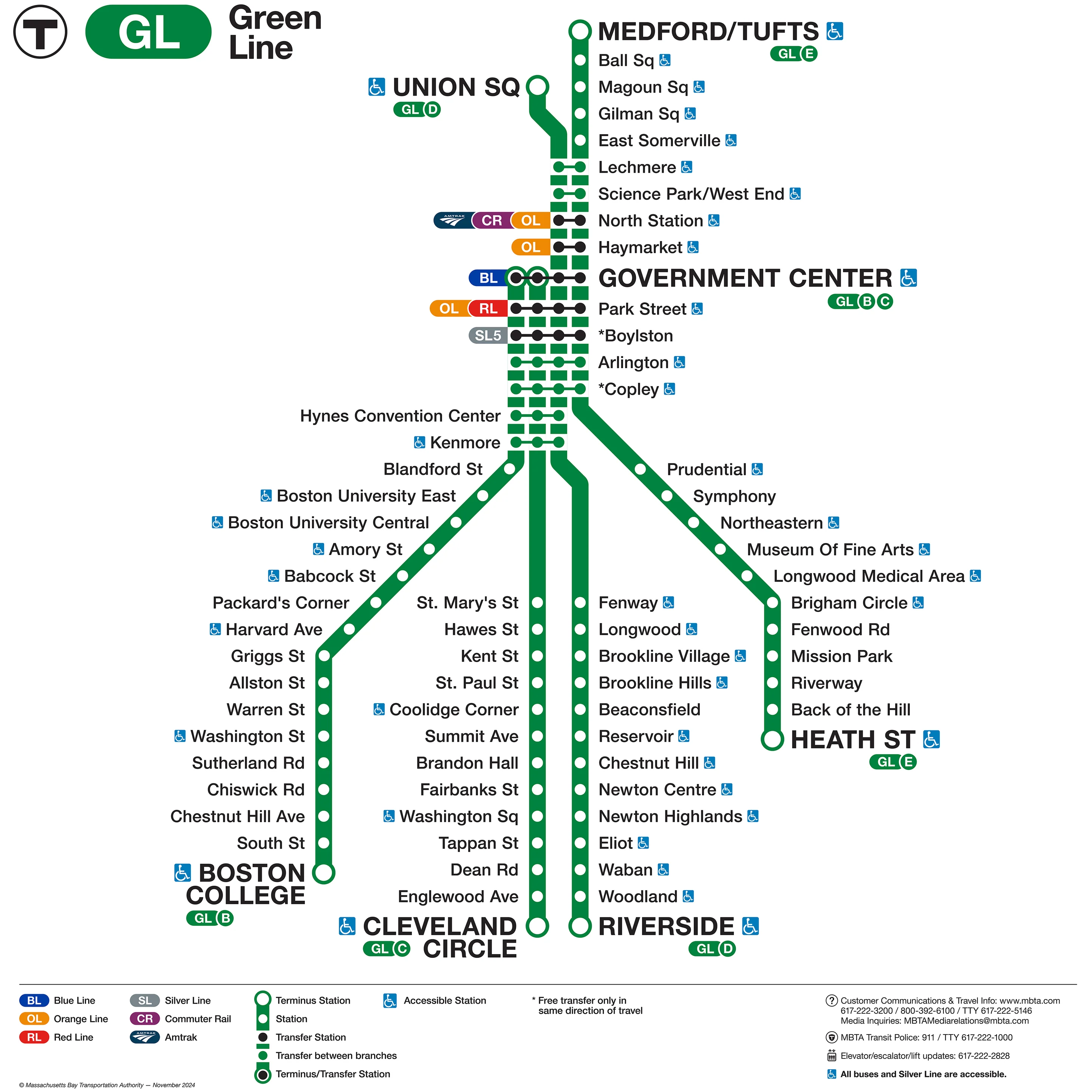 Shockingly, I don’t think this map is available from the MBTA’s official site
https://mbtagifts.com/products/2025-mbta-green-line-map-station-wall-panel-format
This is also why the headsigns2 show stations that aren’t at the end of the lines, since those are saying where the train will actually terminate. I still wish more of this information was on the system map, but a girl can’t have everything.
Luckily, once you know what’s going on, it’s pretty easy to navigate. Generally if I’m going from West to North, I will get on any train that’s going inbound, ride it until it terminates, then transfer to the train I actually need to get to my destination (often home, which is on the GLX3). Going the other direction, I get on any Westbound train, then transfer at Park Street.
Wayfinding on the Green Line
I usually use Google Maps or Transit to navigate, and unfortunately both of those are not super helpful when telling the user which Green Line platform their train will arrive on. Platform signs on the Green Line generally list the direction of travel, and a significant station on the way (usually either Park St4 or the last station before the line branches). For example, Hynes station lists “KENMORE & WEST” and “PARK ST & NORTH”. Unfortunately, this doesn’t really match up to what apps offer for navigation. Google Maps tells me to board an E branch train going to Medford/Tufts, neither of which is listed anywhere on the platform (or obviously in the map in some cases). Transit is a little better, as it at least says if you should be going East or West. If you’re ever in a situation where you’re unsure which platform is correct, check the station listed on each platform sign, then check a map in the station to make sure it’s on the way to where you want to go.
Riding the Green Line
Listen, I’m sorry I keep bringing up the Green Line, but on the oldest subway in North America there’s going to be some weirdness. Despite running on tracks, the western above-ground section of the line operates more like a bus. What do I mean by this? The train doesn’t stop at stations unless there are people waiting or a rider requests a stop (either by pressing a red STOP button or the tan tape on the wall). Operators also sometimes only open the front door to deter fare evasion, which can make it easy to miss stops if you’re sitting facing backwards.
The GLX is half way inbetween the subway section and the Western section in terms of operations. All doors open for boarding5, and the trains stop at all stops unless it’s late at night, in which case the operator will announce that stops have to be requested. Also, the GLX will sometimes run express, often during late night service. If this happens, the operator will announce it. If you want to go to any stops except the last one, get off the train at the next station, and wait for the next one which will be local. There isn’t a particular schdule to when this happens, as it’s done to help with certain operational issues where the trains are too close together.
Mattapan
Looking at the map of the redline, you can see that service extends past Ashmont to Mattapan. This is the thrilling Mattapan High Speed Line, a shockingly historic streetcar service that connects the redline to Mattapan. To ride it, as you leave the station, go through the fare gates and turn left to wraparound the station to the platforms.
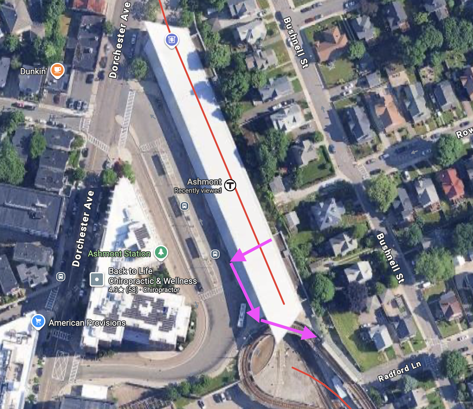 Preview.app is my passion
Fares are technically collected on the train but I’ve never been on one with a working fare box, and either way it’s a free transfer to and from the Red Line6. Stops must be requested by pulling the overhead cord.
Split stations
Most subway stations have either a shared island platform, where you stand in between the tracks for the different directions, or a split platform, where the tracks are in the middle of platforms on either side. The Orange Line has a few stations which are neither, specifically State7, Downtown Crossing, and Chinatown. Due to constraints of building in the dense downtown, the tunnels for the different directions are stacked vertically to keep it more narrow. This also means the Northbound platforms are offset North from the Southbound platforms, since they couldn’t stack the platforms as well8, and so there are often a lot of enterences that are more spread out than usual.
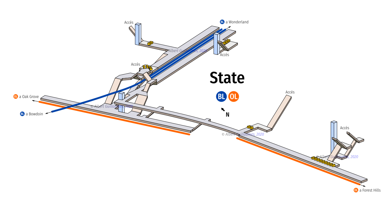 I’m not sure how helpful this is if you aren’t already familiar with the layout, but it’s so cool I couldn’t not include it (http://stations.albertguillaumes.cat)
Downtown Crossing and State have walkways at the end of the platform which connect the two directions, although some street entrances say they only give access to a single platform, which I suspect is to discourage crowding on platforms from people walking through them. Chinatown however, is totally split, and requires you to walk out to the street to get across to the other platform. A top tip is that Google Maps actually shows the locations of specific enterences9 if you turn on the Transit layer.
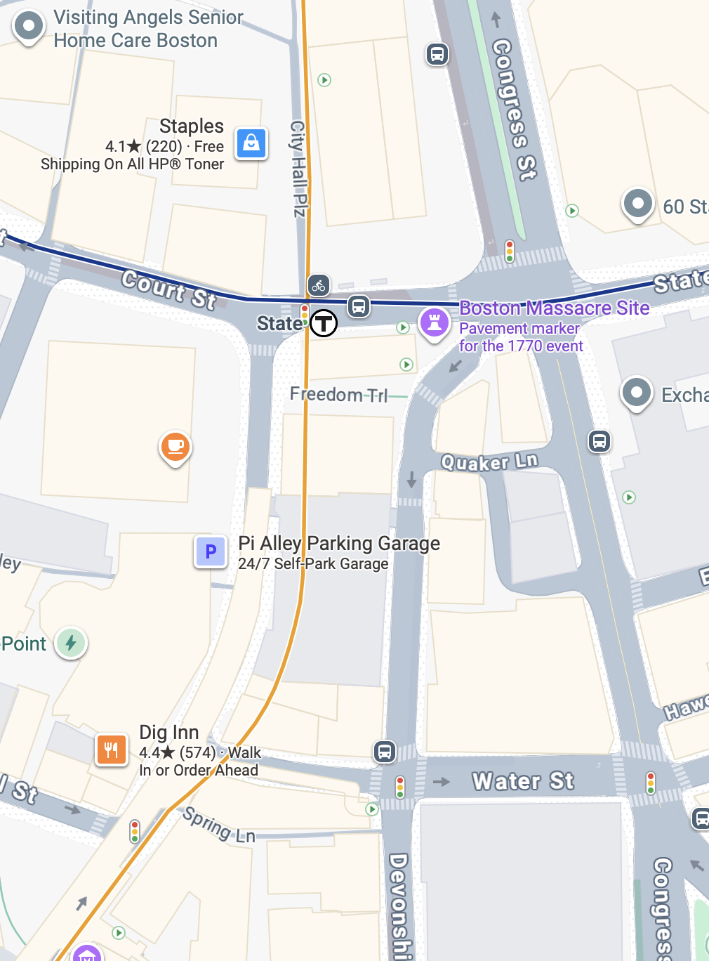 They're the Green triangles facing right in the green circles. I believe exits would be marked with triangles facing left, but Boston doesn't really do exit only stairs
Finally, some street running green line platforms are separated as well, so make sure you’re at the platform marked by the sign for the direction you’re going. Standing by the “FIRST CAR STOPS HERE” sign also always gives me confidence I’m in the right place.
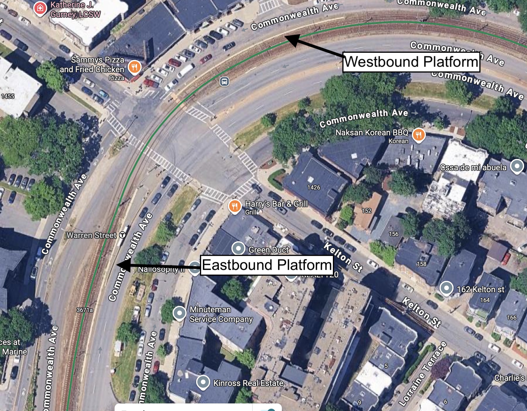 I could credit Google Maps here, but I’d rather live in the fantasy in which I used a drone for these shots
Paying fare
Traditionally, the T and busses ran on single-use CharlieTickets and reloadable CharlieCards10, both purchased at vending machine in stations. Now however, all T stations and busses allow tap-to-pay, using a smartphone or a credit/debit card. Unless you are using a non-standard ticket/pass (such as commuter benefits, paying with cash, reduced fare service, flat rate day passes, or nostalgia) there’s no reason not to use tap.
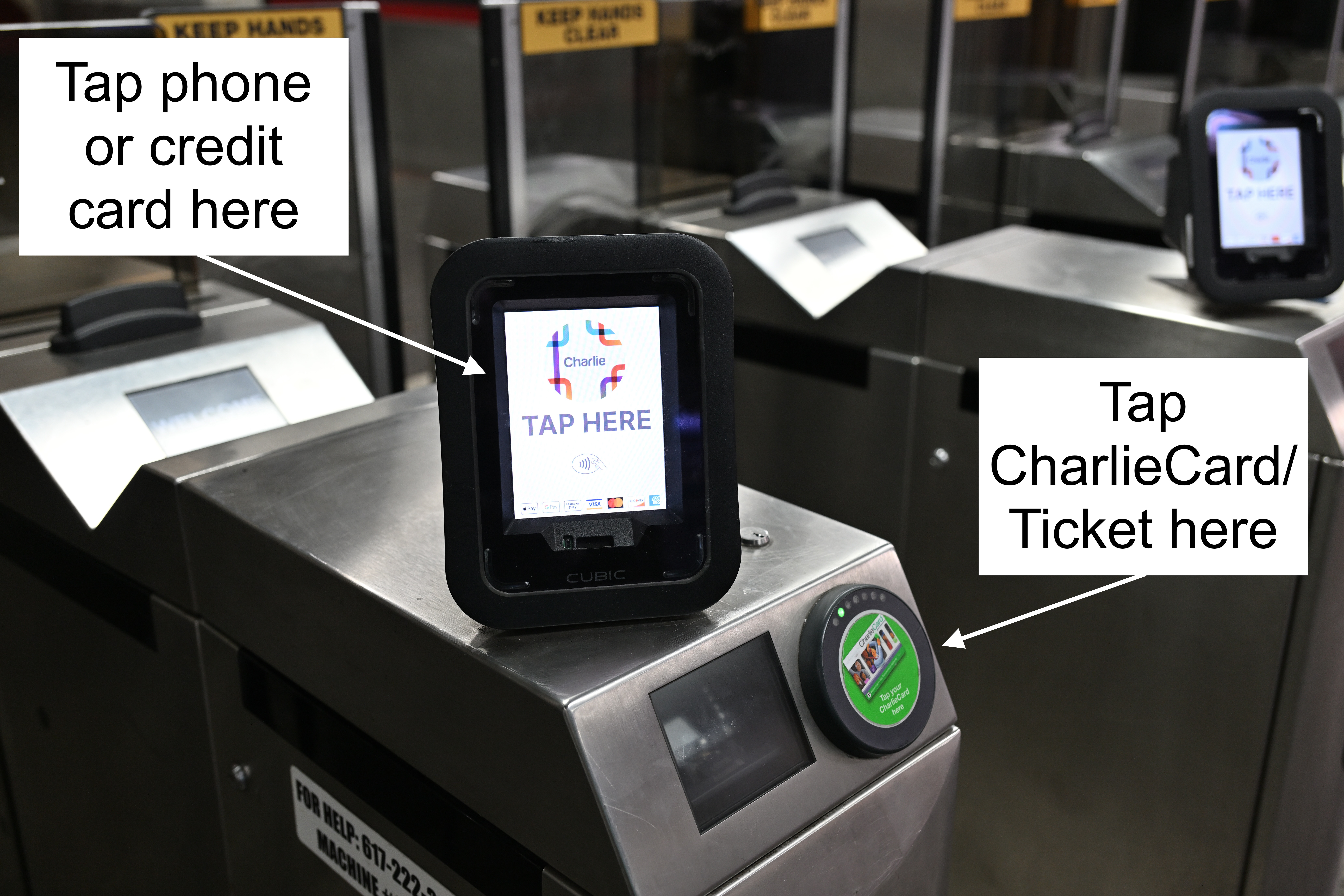 If you die in Preview.app, you die in real life ( https://commons.wikimedia.org/wiki/File:Contactless_Fare_Reader_on_MBTA_faregate.jpg )

If you’re riding the Green or Silver Line, pay as you board unless the station has fare gates, in which case you don’t have to re-tap11. GLX stations say you have to pre-pay your fare without boarding, but that’s not true anymore, just make sure you board at the front if you’re using a CharlieCard.
The commuter rail and ferries use zones, so individual tickets need to be purchased, either using the mTicket app, CharlieCard vending machines, or at the ticket counters in North & South station. I also think you can pay cash on board the train but I’ve never done it before12.
Parking
The MBTA offers cheap and easy parking at many of its outer stations, which is a great option if you don’t want to deal with downtown parking. The MBTA webpage for each station has info on parking including cost and number of spaces. If it lists “Overnight: Available”, it means you can leave your car for multiple days. Stations I’ve used for this include Alewife on the Red line, Wellington on the Orange line, Wonderland on the Blue line, and Newburyport on Commuter Rail (can you tell I’m from Maine?). I generally choose pay-by-plate if it’s available, both because it’s impossible to go over the time limit like if you prepay, and because sometimes they forget to bill you at all.
Getting to the airport
Boston is lucky enough to have a well-connected airport very close to downtown. Because of this, there are a few options for getting to it besides driving or cabs.
Blue line
Airport service is at the aptly named Airport station. However, to actually get to the terminals, you need to board Logan specific shuttles which stop right outside the station. There are actually a few different shuttle routes, which just seems overcomplicated to me. Some shuttles theoretically get to the terminals faster, but honestly I always just get on the first one that stops at where I need to go.
SL1
The SL1 is the only rapid transit line that will drop you off directly at the terminal, so is my preferred option when coming from/transferring through downtown. It’s also free when boarding from the airport.
SL3 & 104 Bus
These bus lines will drop you off at Airport station, so they’re generally only the optimal route if you’re coming from somewhere directly served by them (like Chelsea), or you need to get on the shuttle anyway to go to the Rental Car Center or something.
Logan Express
Your best option if you live in Back Bay, or past i95. Ticket is round trip and parking is pretty cheap everywhere except Back Bay.
Ferry
I’ve never heard of anyone actually using this service. I would imagine the service from Hingham would be quite convenient, or from downtown if you’re whimsymaxxing. Requires a shuttle to reach the terminals.
Bus frequency
The busses in the Boston area are great for getting around areas that don’t have rapid transit lines: they’re far better than the bare-minimum bus service provided in other cities. However, one difference between them and the subway is the variation in frequency. Many lines, including those shown on the subway map, run at least every 15 minutes. However, other lines like ones going further out into the suburbs, only run a few times per day. This can especially be problematic for bus to bus transfers. I find the Transit app to be helpful here, since it’s easier to see how long you will need to wait than other apps.
Reliability
Throughout the 2010s, the MBTA (rightfully) earned a reputation for unreliability and general disfunction. However, I’m happy to say that there have been massive improvements to the system post-COVID.
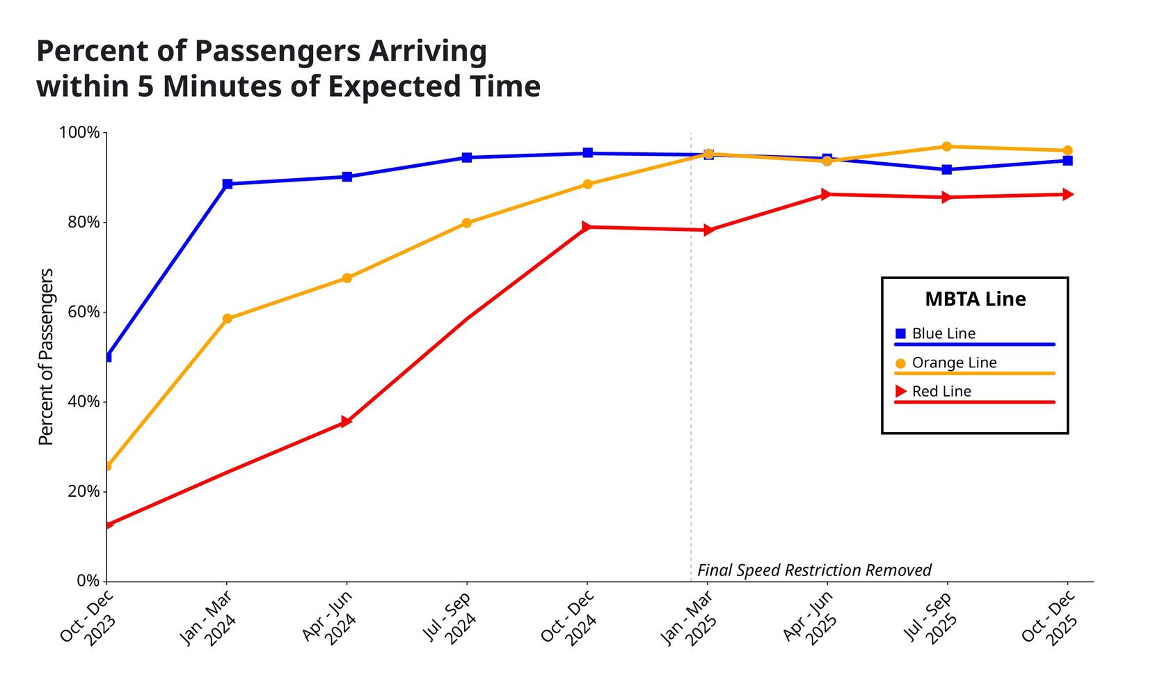 ( https://www.mass.gov/info-details/fair-share-is-making-public-transit-safer-more-affordable-more-reliable )
Trains arrive as frequently as I expect, the online bus tracking is accurate, and multiple people I know rely on the T for their daily commute despite having the option of driving. I don’t mean to glaze the system too much, there’s always room for improvement, but more to emphasize that it’s out of the crisis period that it went through from 2015-2022.
( https://www.mass.gov/info-details/fair-share-is-making-public-transit-safer-more-affordable-more-reliable )
Trains arrive as frequently as I expect, the online bus tracking is accurate, and multiple people I know rely on the T for their daily commute despite having the option of driving. I don’t mean to glaze the system too much, there’s always room for improvement, but more to emphasize that it’s out of the crisis period that it went through from 2015-2022.
Sorry Portland ↩︎
The LED signs on the front and side of the busses and trains, which generally show the terminus of the service it’s currently running ↩︎
The section of the Green Line North of Science Park, which opened in 2022 ↩︎
Park Street is generally considered to be the “center” of the MBTA system, and was historically the last station before the Green Line branched, which is why it shows up on a lot of signage ↩︎
The front door of Green Line trains are on the right side since that’s the boarding side for street running sections. GLX stations were originally designed with fare gates, so they were given island platforms where riders board on the left, thus all doors need to be opened ↩︎
And in fact the only free subway⟷subway transfer in the system, at least until the 2026 Fall Fare Pilot ↩︎
State is kind of a mess all around NGL. Many of the entrances seem almost purposefully hidden, either due to historical preservation or because they’re within the footprint of privately owned buildings. Some are closed weekends and nights with no hours marked on the outside, and those that are open have signs that disagree on if there’s access to both platforms, or just the one closest to the stairs. It’s not my favorite place on the MBTA, if you couldn’t tell. ↩︎
This last bit is speculation, as plenty of other metro systems have stacked platforms for configurations like this. They probably had a good reason for it though ↩︎
Information which seems to not be documented anywhere else online, including the MBTA’s own website! ↩︎
I think it even will refund you if you accidentally tap onto the train in this situation, but I’ve never tried it so I wouldn’t tempt fate ↩︎
There’s also a fee if you pay with cash after boarding from a station that has a ticket machine ↩︎